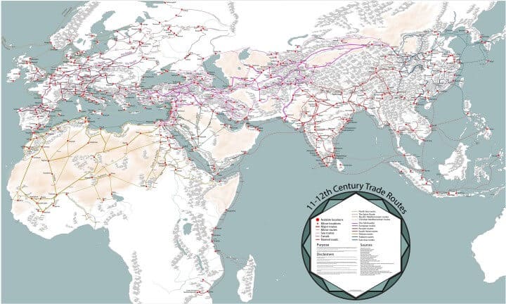
The map above is probably the most detailed map of Medieval Trade Routes in Europe, Asia and Africa in the 11th and 12th centuries you can find online. It includes major and minor locations, major and minor routes, sea routes, canals and roads.
martinjanmansson explains that:
Even before modern times the Afro-Eurasian world was already well connected. This map depicts the main trading arteries of the high middle ages, just after the decline of the Vikings and before the rise of the Mongols, the Hansa and well before the Portuguese rounded the Cape of Good Hope.
The map also depicts the general topography, rivers, mountain passes and named routes. All of which contributed to why cities came to be, and still are, up until modern times.
The high middle ages were a time when the stars aligned in terms of commerce for many areas of the world. In central Europe many German and French cities initiated annual trade fairs, some of which are still active today – most notably in Frankfurt. The Europeans have redeveloped a demand for eastern goods as a result of the crusades in Iberia and the Levant. The Italian city states and some north eastern Iberian cities had shipped the crusaders back and forth in the Mediterranean sea, building up huge fleets and setting up networks of trade all around the Mediterranean shores. The Italians frequented ports such as Alexandria, which had separate trading ports for muslim and christian ships.
The Muslim kingdoms of Southern Iberia enjoyed a great trading relationship with Egypt and the most important sea trade route spanned between Seville and Alexandria. On the way between these two cities, Palermo on the island of Sicily became a meeting point between Muslim and christian traders. The Jewish community were a common middleman between the Christians and the Muslims.
This time saw the rise of the Sahelian cities, just south of the Saharan Desert. These cities became the worlds’ leading exporters of gold which stimulated all the markets of Afro-Eurasia. It is from these cities that Mansa Musa (Keita I) would later depart on his famous Hajj. The gold was mainly transported northward to the North African coast across the Saharan Desert. An eastward trade network towards Egypt and Sudan started to grow during this period.
Moving more eastward the Fatimids of Egypt and the Abbasids of Iraq are both trying to funnel the lucrative trade through the Nile and the Euphrates respectively. The Nile would eventually prove to be the better option since the Persian Gulf was starting to get a reputation for its notorious pirates.
In modern Russia, the many navigable rivers are still the main trade channels even after the decline of Viking visits through the area. The Russian area is a big supplier of Fur to both Europe and the muslim kingdoms to the south. These trade routes from Russia all ended up in the starting nodes of the famous and complicated Silk Road.
The Silk Road is not just one, but many roads that leads through all of Asia, from Constantinople in the west, through Central Asia and the Himalayas, to Liangzhou in the east. During this time, the Chinese Song dynasty was in its height and it was one of those Chinese dynasties that were open to foreign trade and invested in commerce and infrastructure. Foreign trade was mostly concentrated to the southern ports were both Jews and Muslims had their own communities.
In the Indonesian region the Srivijaya kingdom based on the Island of Sumatra was the most influential maritime and commercial actor, but it was in strain competition with the other commercial powers based on the neighboring Java island. The Indonesian region provided exotic spices for the muslim and European world.
In India, which has always had a central role in Afro-Eurasian trade as being the main producer of exotic goods and spices, was also on the rise. Especially in the southern part of India the Chola Kingdom started to expand ever more until finally reaching as far as Sumatra. They were a conquering as well as a commercial kingdom, establishing factories and trading networks wherever they conquered.
The last, but equally important as all the other regions, we have East Africa. This region have yet to see its heyday during this period. But it provided the Indian Ocean countries with gold, slaves and exotic animals. The most notable trade network led from inland Zimbabwean cities to the coastal city of Kilwa, from which most of the African gold were exported.
Enjoy this map? Please share it with a friend:
Also be sure to check out our guide to cheapest card readers in the UK.
Bosco Possum says
Zimbabwe to Sofala, then Kilwa.
Dinakar says
Rohtang Pass is marked incorrectly. It cuts across the Pir Pranjal mountains in Himachal Pradesh, and from to Taxila to Afghanistan!
Ref: https://en.m.wikipedia.org/wiki/Rohtang_Pass
Arrowgrab says
Lovely and interesting map, but I spotted a mistake. There was no city called Budapest in Hungary in the Middle Ages. There were two separate cities, Buda and Pest, facing each other on the western and eastern side of the Danube, respectively. The two only united (along with the third town of Óbuda) in 1873.
Matt says
I suspect the modern city names are being used
Radek says
Nope, I don’t get why some cities are named as they are on this map but for sure these aren’t modern names, at least not in all cases
For example, a Polish city of Wroclaw has German name “Breslau” (why?). Same for Szczecin (Polish) -> “Stettin” on the map (German). In contrast, the city of Lwow (it had this Polish name for almost entire of its history) has its today Ukrainian name – “Lviv”. Another case – today Tallin (the capital city of Estonia) has its old historical name “Reval”.
It seems like the city names are chosen randomly from different times in their history, maybe just in a way that was more comfortable for the author (ex. more comfortable to pronounce, some names in some languages are hard to pronounce).
Anyway, the map itself looks quite cool.
William H says
Because these cities and towns, Breslau and Stettin, were majority full of German speakers (by far) at the time and of Germanic organization at the time even if they were usually under a Crown with predominantly Polish noble ethnic character in medieval times. It’s wrong to think of a country called “Poland” as it didn’t exist. The Polish-Lithuanian Commonwealth was made up of a range of ethnic linguistic groups of which Polish-Slavs were but one. Obviously Lithuanians on the north. Ukrainians in the west, Silesian in the east and Germans in the South. This was the nature of Kingdoms and Empires. The coastal regions in particular were Old Prussians (the original inhabitants of Baltic background and neither of Germanic or Polish/Slavic background). The Germanic people were either there in small numbers but then invited in by nobility to inhabit what was uninhabited lands thereby making that land valuable. Lords and Barron’s want blacksmiths, carpenters, farmers, Cartwright and towns to tax. When there is no one there it’s near worthless.. They were not invaders that displaced anyone. Old Prussians were nether Germanic or Polish/Slavic suffered from a severe plague in the 15th that diminished their numbers by 60% so much it lead to their assimilation by German speakers or Polish/Slavick depending on region though the language persisted till the 18th century. The German speakers took on the name Prussian and much of their culture. When the horrific ethnic cleansing of Germans in the wake of WW1 and in particular WW2 took place it was often of people of old Prussian ethnic heritage that had adopted German. In the binary mind of some nationalists this multi ethnic history is a threat.
It’s important to understand these German speakers were not invaders, they had ended up there by predominantly natural means. In the late 18th century the Polish-Lithuanian Commonwealth allowed Catherine the Greats Russian army to March through the Commonwealth to invade Frederick the Greats Prussia. Frederick was a military genius and defeated Catherine Army after 7 years. No king could tolerate a neighboring kingdom allowing an enemy army to March through it to attack and Frederick the Great defeated and annexed half of the Polish-Lithuanian Commonwealth as he drove out Catherine Army. Frederick the Great welcomed his new Catholic Polish subjects and built a massive Catholic cathedral in Berlin to help make them welcome which is still there. Let’s remember that the Polish Lithuanian Commonwealth was part of Christendom and its Knights marched down to Vienna in the 17th century to defeat a Ottoman Army besieging Vienna.
Korwinus says
Man, this map is supposed to show 11th-12th century world. There was no Polish-Lithuanian Commonwealth that time! There was Kingdom of Poland until 1138 when it was partition to several principalities. Back in 11th and 12th century majority of citizens in Wroclaw were still Polish and the common name of the city that was used was Vratislavia. First town location and after that German immigration was in the beginning of 13th century.
You know nothing about history, you just pretend.
Dani Renan says
As to Budapest: before 1848 Buda was officially Ofen and Obuda, Alt-Ofen.
Athavale says
I dont think that the routes ahown on peninsular India agree with ancjent texta
Caitriona Lambert says
A really interesting map however those coming back and forth to Ireland is perhaps not quite the full picture – we weren’t that isolated! Wiine from Bordeaux was coming into Galway and Waterford – Waterford had the charter for all wine imports throughout the 13th century and into the 15th I think. We also traded with Spain . There was a very well known trade route between Cork and Santander in Northern Spain. this is about the Waterford links
http://www.waterfordtreasures.com/medieval-museum/whats-inside/mayors-wine-vault
Also missing is the route from Wales to Ireland. Many Normans came in to Ireland looking for land ownership via this route. That was certainly 10th century and later on.
Thank you for sharing this with us!
Kennikoh says
A great map and a helpful map. We can see clearly that there was a world trading network long before our times, that east-west trade network was already ancient in the 11th-12th centuries CE, and the trade network will remain into the foreseeable future. Likely, it will become even more important, given the Chinese investment in the Obor.
Pas says
interesting undertaking, but so full of mistakes everywhere that is just not credible…
A bunch of cities at the wrong place (e.g. sofala, quelimane, inhambane) all misplaced. Just take a look at the map today… some of it may have changed, but not all of them, all by hundreds of Kms.
It should be reviewed, and then be very interesting
Stephen Wood says
Just a quick review
-could not find Kyber Pass
– thought Petra was on a major trade route in Jordan
– tin from Cornwall to Mediteranean was a major route
liam says
Your thinking of the wrong time scale.
By the 11/12th centuries represented in the map, Petra had largely been abandoned and was mostly just a curiosity. It’s days of glory had ended by the time of the Muslim conquests which predate this map by 400 years.
And tin mining in Cornwall had been surpassed by that of Devon in this time scale which is undoubtedly the reasoning behind Exeter’s appearance on the map. No point in cluttering the map up too much I guess as its likely much of Cornwall’s output travelled the same route.
Historyan says
Budapest did not exist in the Middle Ages, you are using that name anachronistically. Also, Bratislava did not exist at the time, it was Pressburg or Pozsony, but not Bratislava.
More professionalism, please.
Lars Dahlin says
Nidaros is marked wrong. It should be placed more north.
Rik Jayson Jurcevic says
I love your map. ancient and medieval trade is always interesting isn’t it? We usually only hear or read about snippets here and there but it’s something to see all of those snippets compiled.
It would also be interesting to see the inclusion of indigenous trade routes too. Apart from intra-Australian trade, there’s evidence to show that Aboriginals had regular trade contact with their near neighbours to the north and some (intermittent I believe) trade with Asians and Europeans a little further away. I’m sure there were more than a few other regular indigenous trade routes too. Enough to almost completely cover the inhabited regions of the globe.
louisa says
please can you make one for the sixteenth century – this is brilliant thank you
Benjamin Blandin says
Hi
Would it be possible to obtain a copy of the map, I am pursuing a Master degree in geopolitics and such material would be greatly appreciated !
admin says
You’ll have to ask the original map designer.
Jean Kinnaird Frey says
Is this available framed?
Bruce Hubbard says
Copenhagen Denmark isn’t shown, a miss!
Octavian says
There is a false name of a port in NW of the Black Sea map. Bihorod is a false name, it is a XXI th century name. . Asprokastron was the real name of the port In mentioned period. It is a byzantine name. Reference Constantine Porphyrogenitus, De administrando Imperio,
Mrs. H. Meyer says
Thank you so much for the Near Eastern section of the map. I’m writing a novel set in 1100-1120 and had trouble with trade routes. Even if there are minor errors, this map gives me what I need. I’m also glad you’ve also included the Sahelian routes because another story has been quietly cooking at the back of my mind, which depended on learning about those routes. Thank you!.
Rosanna Cantavella says
Excellent work! Yes, toponyms are confusing. “Alicante” was not a medieval name; Alacant was. Sardinia and Sicily belonged in the Crown of Aragon, therefore one would expect a signal for these routes. More puzzling is: what happened to Menorca?? Menorca had two important ports: Ciutadella and Maó, the last bastion before Sardinia. But, once the imperfections are corrected, this is a very useful map. Thank you so much!
AntonyKE says
Kindly please more information is needed on the TransAfrican trade route passing via Maseno Township in West Kenya (it sits on the TransAfrican Highway of Cape Town in South Africa up to Alexandria in Egypt). The cultural mix is needed considering the role of cultural affiliation in trade routes globally.
Frances Affandy says
Ooooh. Wonderful!
Great invitation for North, Meso-, and South American scholars!
Kingsley says
In 1270 a Jewish merchant Jabob of Ancona took Italian goods to Quanzhou mostly by sea but crossed the Syrian desert from Damascus to Baghdad and then down to Basra. The caravan passed through At Rutbah which was in the 1920’s named Rutbar Wells where Francis Chichester landed in 1929 and an engineer of Imperial Airways helped repair the DH 60 Gypsy Moth. The route followed the Wadi Hauran to Rutbah Wells and then to Baghdad.
The route from Damascus to Baghdad almost due East that follows as far as I can see the current Highway 1. It was a major trading route in 1270 and it is now.
See “City of Light” by David Selbourne 1997
Jeffrey Bristol says
Very good work, but from my area of specialty (the Sahara and more precisely the Adrar) there is a light mistake. Ouadan and Wadan are the same place, one is just the French spelling and the other the English spelling. What is listed on the map as Wadan should actually be Chinguetti.
Jeffrey Bristol says
Also, I am not sure Chinguetti should be on the map for this time period. It’s rise on the caravan routes I do not believe brought it into prominence until a couple of centuries later than the twelfth.
HELP ME with my homework says
Trade Routes of the Middle Ages
Directions: During the Medieval Period, several major trading routes developed in Europe that connected its major cities. Use the “Scribble” tool to draw in these trade routes on the map below and identify the major cities/trade centers below. Then, identify other trade routes that connected Africa and Asia, the goods traded along these routes, and their effects.
Goods Traded
Other Trade Routes in the Middle Ages
Effect of Trade
Melinda Van Fleet says
Great map. I’m reading Peter Frankopan’s book The Silk Roads, and this map helps me see the routes, and see more cities.
DAVID THOMAS says
Glad to see Firuzkoh (the Ghurid dynasty summer capital at what is now modern Jam) on the map in the heart of Afghanistan. We found a possible Song dynasty ceramic sherd there, as well as mina’i and other wares from Kushan and elsewhere in Iran, not to mention lapis lazuli from Badakhshan and a Saljukid coin. It is questionable, however, whether there was a direct route from Herat through Firuzkoh to Bamiyan and Kabul, since gorges along the Hari Rud prevent easy travel along the valley.
It is also notable that Kilwa coins have turned up in the Wessel Islands off northern Australia!
Bagel Supplier says
Bagels are very tasty.
Tom Wall says
I would love to see an atlas like this.
Kenne says
this was horrible